 |
| We survived from Bukit Chenunag! |
Bukit Chenuang (Cenuang) is located at Hulu Langat, Selangor, with a height of 850m/2788ft. Driving to Bukit Chenuang takes approximately 1.5 hour from Klang but only 45 minutes from KL Town. Although Bukit Chenuang is categories as hill by name, but do not underestimate this hill as it will be quite difficult for a beginner (like me). It took us 2.5 hours to reach the peak and 2 hours from peak to ground with a total of 15 km distance. Chenuang is sitting inside Congkak Recretional Park which previously is known as unknown hill in Sg Congkak.
 |
| Sungai Congkak |
 |
| Bukit Chenuang Hilltop signboard |
Getting There (90 minutes from KL Town)
To hike Bukit Chenuang, there is number of routes to the peak, but we took the route from Sungai Congkak Recretional Forest Camp 6. To get to the starting point, drive on Jalan Hulu Langat towards Kuala Pansoon. Pass Hulu Langat town, then go straight to Pekan Batu 18, after 4km, turn left into a small road that leads to Sungai Congkak Recretional Forest.
At the end of road is the open car park. A small fee of RM1 per person for entrance and RM4 for carpark is compulsory. We park our car outside and then realize to reach the entrance of Bukit Chenuang is another 2km extra to walk from Entrance of Congkak Recreational Park. You can also drive your car inside with a fee, I will recommend to do so to cut the amount of walking.
 |
| Entrance of Congkak Recreational Forest |
You find the facilities like toilet, camp site, bbq area along the side. Some facilities have to pay for a fee which you can refer the price rate at the entrance.
Besides, for those who are looking for recreational holiday you can rent a chalet here and they offer a BBQ are in front of each Chalet.
 |
| Chalet |
However, some of the toilet here looks so creepy which I believe no one will be using it. :P
 |
| Toilet......... |
 |
| Beautiful Decor from the toilet |
Keep going from here until the end of this route you will find the entrance for the hiking trail.
Hiking Up
Here's the camp 6, which also the starting point for the hiking trail. When you reach the pondok as shown in red circle, look at your left hand side, you will see a small and less steep road as shown in picture below.
 |
| Camp 6 Entrance |
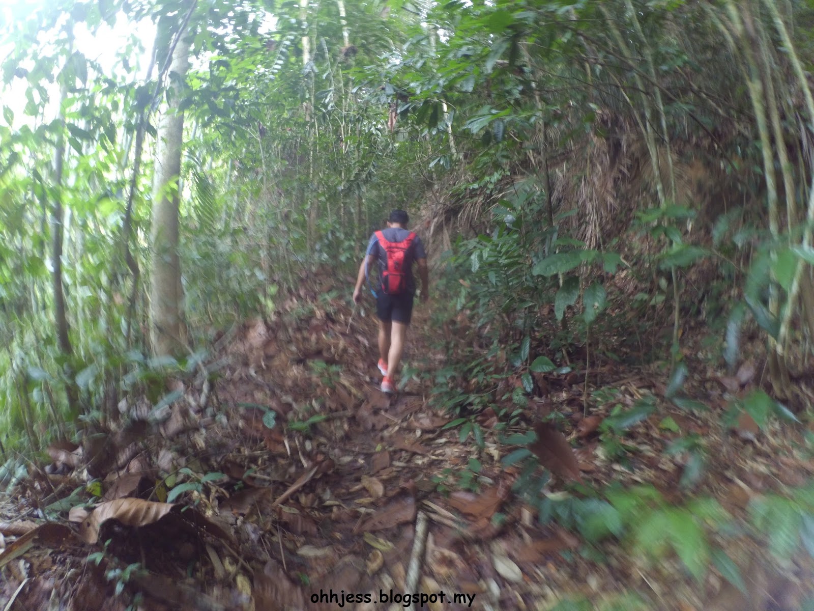
For the first hour of our hike, we cross by a lot jungle trekking and river trekking. After the river crossing, the trail become harder with very steep steps, fallen bamboos and thorny plant. Due to this hill is not one of the famous hill in Malaysia, most of the marker is already fall off and left only few ribbon sign to lead us to the peak.
About 1km, we encounter our first lost in the wood. There is a fallen log which block our way, overpass the log and keep to the left. After that, we come across a small river, turn right then we begin our steeply hike.
Along the way, you will go cross a very beautiful bamboo forest, then back to normal rainforest.
 |
| looks at the "senget" (bend) bamboo, so artistic |
There is few area you have to knee down and crawl over the fallen bamboos, be careful for thorny plants around your and fire ants on the bamboos of course my unexpected guest on my neck - 3 leeches. Luckily I was sweating that time, the leeches still finding way for parking and my buddy had secretly help me removing and only mention after finished the hike
 |
| Fallen Bamboos credited to James - for the first sight I see this photo I laugh damn hard for my supermodel pose but please ignore that tummy :P |
 |
| credited to Song - James's ____ |
Besides leeches, the ants and bugs are very friendly as well, maybe they had not met human for too long. When you reach this open area with a big log, the peak is just 1 hour away, and the hill will go from moderate to hard.
 |
| First and only checkpoint - the big log |
 |
| Resting for snacks |
From here, need to be careful for stepping into the holes under the fallen leaves also roots and rattan which may hook you down.
 |
| The marker have to replace by a new one as soon as possible :( |
The peak can fit a maximum of 25 people or else it will be very jammed to move around, we reach the hilltop and met another two hiker, seems like they are having the same struggle of crawling and finding way like us.
 |
| Small top with a metal shelter |
We bring small cooker and instant mee cup to give ourselves a small lunch before going back for jungle trekking.
 |
| Preparation hek hek! |
 |
| This is Song - Most of the equipment is carried inside his big backpack |
 |
| Wefie for our mee cup celebration! |
Hiking down the track will take you another 2 hours but please take it slow and refrain yourself from jumping down the ledges. The pressure on your knee from landing will be very damaging in the long run. Once you reach the river at the bottom, it’s time to enjoy yourself with some swimming in the cool freshwater river.
 |
| Yeah only two of them is playing, me and Ong rather sitting, but because Ong had bend her ankle, need some rest |
To sum up our hike for today, it is not difficult but very challenging. For myself, I wouldn't feel like want to run into this jungle for another time. Despite it is not necessary to hire a jungle guide, but I would recommend to have one experience hiker so that you won't lost in the jungle. Without knowing much clearer info about this hill before our hike, I can say we do not successful conquer this hill but we manage to survive from this hill.
 |
| Our expression had said it all about this hill HAHA |
 |
| James, Sue Li & Me - Most of the photo above is credited to James |
Things to Prepare:
- Water 2L
- Isotonic Drinks
- Chocolate and energy bar
- Proper hiking shoes
- Hiking stick (recommended but optional)
- Raincoat (optional)
- Extra change of socks
- Extra pair of shirts and pants for changing after hike
- Any Mobile Apps which can keep track your location without using data (I am using RUNTASTIC)
Starting Coordinates: 3.237967N, 101.823085E
Difficulty: Moderate to Hard, route is not defined
Average Completion Time: 4-5 hours (3 hours uphill and 2 hours downhill)
 |
| The only 6 of the day :) |
If you have any questions, please feel free to drop them at the comment section below. Thank you! :)


can hike before sunrise?
ReplyDeletetatanium-arts.com - Titi Athletics
ReplyDeleteTATIANA ARCADE. $18.99. TATIANA titanium cup ARCADE. titanium glasses frames $18.99. TATIANA ARCADE. $18.99. titanium piercing jewelry TATIANA ARCADE. titanium key ring $18.99. TATIANA aftershokz titanium ARCADE.